Geofencing for vehicles: what it produces, and where it goes wrong
A geofence is a boundary drawn on a map that software can test a position against. Draw one round a customer's yard, and every time a vehicle's reported position moves from outside it to inside it, something can happen: a row in a report, an alert, a timer starting.
That is the whole of the idea, and it is worth being precise about what it gives you, because it is not what most descriptions suggest.
What a geofence actually produces
Use this diagram
Free to use on your own site, in a report or in training material, as long as the credit link stays on it. Paste this where you want the diagram to appear.
<figure>
  <img src="https://fleetoptix.co.uk/diagrams/geofencing-for-vehicles/0.svg" alt="A map showing a vehicle's route crossing into and out of a boundary drawn around a customer yard, with the entry and exit times marked, and three panels beneath showing the arrival time, the time spent inside, and the departure time." loading="lazy">
  <figcaption>
    <a href="https://fleetoptix.co.uk/blog/geofencing-for-vehicles">Geofencing for vehicles: what it produces, and where it goes wrong</a> — diagram by
    <a href="https://fleetoptix.co.uk">FleetOptix</a>
  </figcaption>
</figure>Or take the file on its own: download the SVG.
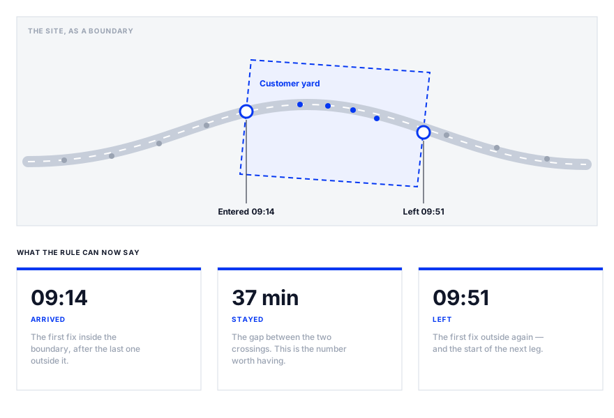
A geofence does not tell you where a vehicle is. The tracker already does that, continuously, and a map with a moving dot on it answers that question better than any rule ever will.
What a geofence does is convert that stream into events with times on them — arrived, left, and by subtraction, stayed. Those three go in a report, get compared against a plan, and can be counted across a month. A moving dot cannot do any of that.
The dwell time is usually the valuable one. How long a vehicle actually spent at a delivery point is the figure nobody has, it is the basis of most demurrage conversations, and it is almost impossible to collect honestly by asking.
The four parts, and why each one matters
- A boundary. A shape with coordinates, drawn by hand on a map or generated round a point with a radius.
- A position source. Usually GNSS — GPS and its siblings — sometimes helped by mobile network or Wi-Fi data.
- A comparison. Something that repeatedly asks whether the latest position is inside the shape.
- A rule. What to do when the answer changes, which is the only part that does anything useful.
Every one of those is a place it can go wrong, and three of the four are invisible from the user interface. You draw the shape; you do not choose the fix accuracy, you rarely choose how often the comparison runs, and you find out about both from the output being wrong.
Where it goes wrong: the fence is smaller than the error
Use this diagram
Free to use on your own site, in a report or in training material, as long as the credit link stays on it. Paste this where you want the diagram to appear.
<figure>
  <img src="https://fleetoptix.co.uk/diagrams/geofencing-for-vehicles/1.svg" alt="Two panels. On the left, a boundary drawn tightly around a gate, smaller than the accuracy circle of a satellite fix, with position estimates scattered on both sides of it and a count of 41 arrivals overnight. On the right, the same vehicle and the same scatter inside a boundary drawn around the whole yard, producing one arrival." loading="lazy">
  <figcaption>
    <a href="https://fleetoptix.co.uk/blog/geofencing-for-vehicles">Geofencing for vehicles: what it produces, and where it goes wrong</a> — diagram by
    <a href="https://fleetoptix.co.uk">FleetOptix</a>
  </figcaption>
</figure>Or take the file on its own: download the SVG.
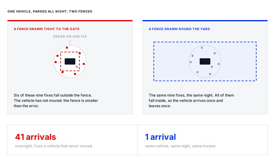
A satellite fix is not a point. It is an estimate, and under a clear sky a consumer-grade receiver is typically good to a few metres — worse beside buildings, under trees, in a yard with a steel-clad warehouse on one side, where signals arrive having bounced off something first.
So if the fence is drawn tight to a gate, a vehicle parked near it will report positions on both sides of the line all night without moving an inch. Every crossing fires the rule. By morning there are dozens of arrivals at a site the vehicle never left, the alert has been ignored for a week, and somebody has concluded the tracking does not work.
The tracking works. The geometry was wrong. The fixes are these:
- Draw round the whole site, not the entrance. A fence should be comfortably larger than the error you expect at that location.
- Require a minimum dwell before an arrival counts — a vehicle that is inside for thirty seconds and out again has usually driven past.
- Use a hysteresis gap where the software offers one: a slightly larger shape to exit than to enter, so a position sitting on the line cannot flap.
- Never fence a gate, a weighbridge or a bay. Those are smaller than the error and will never work.
- Check the output for a week before anybody is asked to act on an alert from it.
Three more failures worth knowing about
The accuracy problem is the common one. These are the ones that catch people who have already fixed it.
- Polling interval. A vehicle at 50mph covers about 22 metres a second. If positions arrive once a minute it has moved over a kilometre between them, and a short stop inside a small fence can happen entirely between two fixes — so it never happened.
- Ignition-off reporting. Many units report far less often, or not at all, with the engine off. An overnight dwell can therefore be bounded by a fix from before shutdown and one from after start-up, which is not the same as the vehicle having been there in between.
- Overlapping fences. A yard inside an industrial estate inside a town means one crossing fires three rules. That is fine until somebody counts arrivals.
None of this makes geofencing unreliable. It makes it a measurement, with the error characteristics any measurement has, and the mistake is treating its output as fact rather than as evidence with a tolerance on it.
What it is genuinely good for on a regulated fleet
Most writing on this is about productivity. On an operator's licence there are narrower uses that are worth more, because they produce evidence rather than insight.
- Where vehicles are actually based. A fence round each operating centre shows where vehicles spend their nights, which is the question asked when a licence is reviewed and the one operators answer from memory.
- Out-of-hours movement. A vehicle leaving a yard at 02:00 on a Sunday is either a job nobody recorded or a problem, and both are worth knowing about tonight rather than in a month.
- Dwell at customer sites, as the basis of a demurrage claim or a route plan that matches reality.
- Unplanned stops, as a prompt rather than an accusation — a long stop somewhere unexpected is a conversation at the end-of-shift debrief, not a disciplinary.
- Workshop attendance. A fence round the maintenance provider tells you a vehicle actually went, which is a useful cross-check against a vehicle recorded as off the road.
And what it does not prove
This is where geofence data gets oversold, and it matters because the things it cannot show are exactly the things a compliance system is asked for.
- Who was driving. The fence saw a vehicle. The tachograph saw a driver card, and the two are not interchangeable.
- Whether the drivers' hours rules were met. The tachograph record is the legal one; a geofence timestamp is at best a cross-check against it, and a contradiction between them is a question rather than an answer.
- What happened at the site. A vehicle was inside a boundary for 37 minutes. Nothing in that says a delivery was made, a walkaround check was done or a defect was reported.
- That a vehicle is roadworthy, which no position data has ever indicated.
Which is the same division that separates telematics from a compliance record generally: one answers where and how, the other answers what was done and what is due. A geofence is firmly on the first side of that line, and a rule that implies otherwise is a rule that will be believed at exactly the wrong moment.
The part most guides leave out: it is personal data
Tracking a vehicle driven by an identifiable worker is processing that worker's personal data, and in the UK that brings the ICO's guidance on monitoring workers into play. This is not a footnote. It is the part that generates complaints, and it is absent from almost every vendor explainer on the subject.
The points that bear most directly on a geofence, from the ICO's own guidance:
- Workers have to be told about vehicle monitoring, and so do passengers.
- Where private use of a vehicle is allowed, the ICO's position is that monitoring during private use will rarely be justifiable.
- Monitoring driving behaviour, or using cameras or audio, is treated as high risk and requires a data protection impact assessment.
- So does any tool that uses analytics to make inferences, predictions or decisions about drivers — which covers a good deal of what is sold as driver scoring.
- Where the law requires the record — a tachograph, for instance — legal obligation is available as the lawful basis. A geofence is generally not in that category, so a different basis has to be identified and written down.
- If a DPIA finds a high risk that cannot be reduced, the ICO has to be consulted before the processing starts.
In practice the operators who get this wrong are rarely acting in bad faith. They buy a tracking product, switch on the features it came with, and discover eighteen months later that nobody wrote down why, that the drivers were told about the tracker but not about the rules running on top of it, and that the vans go home with people at night.
Check the current ICO guidance rather than this page before you configure anything — it is the kind of detail that moves, and the consequences of getting it wrong land on a named person in your business.
Before you turn it on
- Write down the question each fence is meant to answer. A fence without a question becomes an alert nobody reads.
- Decide what the rule does. An email to a mailbox nobody owns is not a rule, it is a filter folder.
- Draw round sites, not gates, and give every fence a minimum dwell.
- Run it silently for a fortnight and read the output before anyone is asked to act on it.
- Say what happens on an alert, and who it happens to — the same discipline that makes a tracked figure different from a number on a dashboard.
- Do the data protection work first, not after the first complaint: tell the drivers, record the basis, and assess the risk where the ICO says to.
Done that way a geofence is a quietly excellent instrument — it produces a small number of dated, countable facts about where vehicles were, and those are hard to get any other way. Done the other way it produces forty-one arrivals a night at a yard nobody visited, and a driver who has worked out that the system is wrong about everything.
- A geofence does not show where a vehicle is. It turns a position stream into an arrival, a departure and a dwell — and the dwell is the figure that is hard to get otherwise.
- It has four parts: a boundary, a position source, a comparison and a rule. You control the first one; the others fail silently.
- Most trouble is geometric. A fence smaller than the error on a satellite fix reports a parked vehicle crossing it repeatedly, all night.
- Draw round the whole site, require a minimum dwell, and never fence a gate, a weighbridge or a bay.
- It cannot show who was driving, whether drivers' hours were met, or what was done on site. The tachograph and the maintenance record answer those.
- Tracking an identifiable worker's vehicle is personal data. Tell them, record the lawful basis, and do a DPIA where the ICO's guidance says one is required.
- ICO: data protection and monitoring workers — the overarching guidance, including transparency and lawful basis
- ICO: considerations for different methods of monitoring workers — the section on vehicle monitoring, private use, driver behaviour and when a DPIA is required
- ICO: surveillance in vehicles — where cameras or audio are fitted alongside tracking
- ICO: when do we need to do a DPIA? — the threshold, and the duty to consult the ICO where a high risk cannot be reduced
Links checked 24 October 2026. Published guidance changes; where a figure matters to a decision, confirm it against the source rather than against this page.
About this article
The FleetOptix team
Written by people who work daily with fleet operators on drivers' hours, tachograph records and the paperwork that holds up under a DVSA inspection. Regulated detail is attributed to the body that sets it rather than asserted here, and the sources are listed above.
- Published
- 24 October 2026
- Last revised
- Not since publication
- Topic
- Operations
How this is researched, dated and corrected is set out in our editorial standards. If something here is wrong or out of date, email hello@fleetoptix.co.uk — corrections to a regulated detail are made as soon as we can confirm them, and the revision date above moves when they are.